 Down and back up
8 - 11 June, Ian
I ended the last entry with the comment that you
would only hear from me before next weekend if something went
wrong...
On Wednesday we started our walk well, picking up a taxi in Calvi that dropped us off in Calenzana by 6:15 a.m. As I wrote previously, the first day's walk features a significant continuous ascent. Although it was solid work everything went well. The landscape was fabulous all day, and for much of the day we had views back over to Calvi and I was imagining the girls playing on the beach. And although it was bright and sunny, the first half of the day's walking was done in the shadow of the first mountain that we ascended and the remainder of the walking benefited from plenty of tree shade, so the intense heat that's the abiding memory of my last assault on the GR20 wasn't a feature. (It turns out that it wasn't a feature for the girls on the beach either - it was much cooler there than it has been and winds cleared the beach so that they had it to themselves.)
Pretty much every walk I've done in Corsica features a gruelling steep climb zigzagging up to a remarkable viewpoint and this was no exception, with the walk up to the first col (or mountain pass) at 1,250m being exactly this. But at the top we could take a rest and look over Calvi and the coast in one direction while on the inland side we could check out a horseshoe of mountains and the valley beneath that we had to skirt round next. After a gentle walk around this horseshoe we started another climb to escape it, this time encountering the other staple of walking in Corsica: clambering over large granite boulders. After a few hours of this we got to another grassy col with another panoramic view, which soon extended over to the refuge that we stayed in (refuge d'Ortu di u Piobbu - Corsican is neither French nor Italian), and again we had to skirt just under the top of a horseshoe of mountains to reach it. Incidentally, for any plant lovers I'm not sure if I've noticed before how many hellebores there are around the hills here - I think that I've developed a liking for these since I last walked seriously in Corsica (which would be when Paula and I did the Tra Mare e Monte route).
Many people doing long distance walks and most people I've met on the GR20 have the mentality of getting up super-early and walking super-fast to get the day's "stage" over with. We don't have this approach. In Paula's case it's because she's asthmatic and likes to start off the days steadily to regularise her breathing and to keep up an even pace. In my case it's because I'm usually doing these walks in my limited and valuable holiday time and want to enjoy it. When Pete and I did the walk previously this became a lively discussion point on one heated occasion, after which we achieved a meeting of minds. Anyhow, on Wednesday despite a pace that seemed almost slack we finished after 7.5 hours, which is only 30 minutes longer than the Lonely Planet guideline - since we'd set off just before 6:30 this got us in at 2 p.m. so you can see that there's no need to yomp along at full assault speed.
As we haven't done any formal exercise since we left home we were concerned that we may have lost the edge of fitness over the past couple of months; but when we arrived at the refuge Paula was only as tired as you'd expect after a day's hard walking and my satisfaction at being back up in the Corsican hills made me feel sprightly.
At the refuges you can either throw your sleeping bag onto wooden palettes or camp or bivouac outside (this is forbidden in the rest of the national park through which the GR20 passes). The campers (who included the three Irish guys I'd met on the beach) often keep themselves to themselves, while those staying inside, knowing that they'll probably be running into each other for at least a week, tend to develop a camaraderie. In the evenings we eat together - either, like us, taking the menu available at the refuge or cooking up food that has been carried in. Our group broke approximately into two groups, one of which spoke German and the other of which talked sometimes in French but mainly in English (this started before we arrived since one of the more loquacious chaps was a Dane who speaks perfect English but no French). This latter group included an outstandingly nice French couple whose three daughters were at home with the grandparents in Nantes, it being their custom to take their annual holidays without their children. I'd guess that we were at about the average age in the refuge - it was a more bourgeois mix than you might expect with fewer Pennine Way-style adventurous youths.
The only really bad feature of the refuge was the loo. Those politicians who are casting around for ideas about how to generate popular enthusiasm for new forms of wide-scale government intervention in our lives might do better to propose a minimum (UK-based) European standard for toilets and postpone their attempts to "harmonise" taxes, create a continental army and stipulate the acceptable curvature of bananas until they score some successes here. For better or worse, the loo was also a couple of hundred metres from the refuge.
Actually there is another bad aspect of refuge life (which is not amenable to Eurocracy) - the snoring. If you get more than a dozen people together at night the chances are that at least one of them snores really loudly. On Wednesday night he was next to me and I didn't get much sleep.
Thursday began with an ascent over boulders to the next valley and then we passed most of the morning making our way up over boulders to a col at the head of the valley. As on the previous day, we walked steadily but not rapidly. At one point as I took off my rucsac the mouthpiece at the end of my water bottle tube flicked off and I spent ages failing to find it in the rocks. Any of you who use one of these will know what a pain this is - instead of having my 2 litres of water centrally distributed in my pack and with immediate access I had to now switch to a single litre pack in one side of my rucsac that required a stop every time I wanted to get at it. We also experimented with walking poles. The majority of people up in the hills use those telebatons that look like ski poles. I've always thought they look a bit ridiculous but we fashioned a pair each from wood that was lying around. I started off with one made from birch and then supplemented this with a hazel pole of the same size (you want them oxter height) that that had a more reassuring heft. If you use poles I'd be interested in your experience. It seems to me that they undoubtedly save the impact on your knees on severe descents but that you lose your natural balance (we're not used to being quadrupeds) and become less nimble with them. I'd bet without knowing the facts that no-one who sets course records for this type of walk uses them. I'd also bet there are accidents arising from the things slipping when you lean on them.
As we faffed around virtually all of the walkers who hadn't set off before us (which was most of them) passed by.
When we reached the col the terrain changed totally. The next section of the trail featured a ridge line of rocky spires that we needed to traverse to get to the head of the next valley. The other change that hit us at this point was in the weather. Here's the last photo I took on Thursday showing Paula (the dot in the lower right) ascending the col:
We'd just climbed up round the head of the valley to the right and clambered over the crop on the left centre, while the severe drop to the left forms the head of the next valley we had to skirt.
As we rounded the col and headed over towards the ridge line the gathering cloud turned to hail. Expecting the sort of hail that you get at home, which spatters against your windows or windscreen for 10 minutes and then stops, we put our cagouls on over our vests.
The trail line next weaves sinusoidally along the rocky crest, periodically switching from one side of the ridge to the other. In fine weather this would give you a tremendous view either side of the ridge line across a dramatic mountainscape, and we did initiallly get a sense of it. However, as the cloud closed in all that we could see were the steep slopes on either side. At some surreal moments we could still see distant lowlands running right down to the coast in glorious sun even as black clouds and hail encircled us.
Walking along the ridge was not straightforward. Usually this would be challenging in an exhilarating way, in the way that the girls enjoy scrambling over those rocks at the beach that you're worried might just be a little bit too dangerous. As we continued, though, the hail just came on harder and harder and started to settle quickly. At one point I cupped my hand to give Paula a boost and, even though we were in one of the most sheltered spots, by the time Paula had declined the offer my cupped hands were already full of large hailstones. (Surprisingly, since I found many of the hoists over the rocks a stretch, it turned out that Paula never needed help.) The rocks lost traction, we didn't know whether the hail we stood on was firm and our hands started to become numb with cold. And we were at over 2000m with severe drops either side.
The books all advise you to give these sections a miss if the weather is bad. They don't tell you what to do if you're up the top and it's just as hard to return as to continue. The first decision was when to take off our cagouls - thus losing the layer of trapped warm air - to put our fleeces on to retain more heat. Fortunately, we made this trade at a sensibly early juncture. The other decisions were harder. At what point do you stop and wait for the weather to pass? You'd lose daylight and heat and watch the hail pile up on the ground all the time you stood still but there must be a point at which continuing is too risky. Then is there a point at which you bivvy out? Again, you'd only be getting colder while you lay there but you must reach a time when it's the least dangerous thing to do. And what about trying to find a route directly down off the mountain? The plus is that you could try to find a spot where there was more favourable weather and less risk of accident, but you would be likely to get lost and much less likely to be found if it ever comes to a search. (Unlike our walks in England where we rely on map-reading, since the GR's are so well signed we don't pack maps.)
Most of the other walkers had already completed this stage by the time the hail came down. The Irish lads were the only other people we saw up there: they came past just after the hail started and before it got too troubling. It turned out that they were squaddies, one of whom is an ex-member of the French foreign legion (the muscular guys who run all over the GR20) and another of whom is a professional mountaineer. Although not pounding along at their pace we made good progress along the ridge-line through the hail, warming up our fingers as best we could and resisting any temptation to take a break. Eventually, after a couple of hours, the hail stopped. I felt warm in my fleece, I could see the clearing views, I ate half of one of Dr Gillian McKeith's energy bars (a high-tech taste-positive Kendal mint-cake) and felt terrific. We soon finished traversing the crest and descended to the col at the head of the valley leading down to the refuge de Carrozzu, our Thursday night destination.
The descent down the valley is described by Lonely Planet as "tedious". In fine weather I can imagine that it may be an enjoyable end to the day's walking as the vegetation soon picks up again and the trail passes through the lush aromatic shrubs and trees of the maquis. But when it's wet you can't spend too much time admiring the scenery. The path alternates between loose (wet) granite scree and smooth (wet) granite boulders. Wet granite has very little adhesion, as some of you will know from your kitchen work surfaces, and if you're walking downhill on an uneven friction-less surface you're likely to take a few tumbles. I escaped but Paula fell into a spiral of tiredness leading to falls leading to bruising leading to more tiredness leading to more falls. We ended up taking the last stage extremely slowly, and by the time we reached the refuge we'd been walking for 10.5 hours.
We threw our bags down, checked in and each had a large bowl of hot spiced wine. The others, who had only had a quick soak of rain at the end of their final descent, had been a little concerned about us and clapped us cheerily as we walked in. Our gear had been excellent - our cagouls, which are so much lighter than any I've had before, kept our upper bodies bone dry, our fleeces kept us warm and our boots remained dry and comfortable all day. Considering the amount of back and shoulder trouble I've had in the past, my rucsac had been remarkably untroublesome, too.
Over dinner we sat down and discussed what to do the next day. By morning there was no choice. We had another day of similar walking ahead, followed after that by the day that most walkers fear. (There is a hanging valley you have to scramble in and out of called the Cirque de la Solitude, and, having done, it unlike the other walkers in the refuge, I recall that the most fearsome aspect of it is the name; but it's not a walk in the park - except that technically it is.) And the weather was forecast to be the same. Since Paula was still sore, bruised and exhausted from the previous day we couldn't continue.
In planning our exit we benefited from the difficulty of fitting the whole walk into two weeks. Even in our party only the French couple, to my knowledge, planned to walk all the way to Conca, the remainder planning to finish at Vizzavona. The reason for this is boringly logistical - by the standard route it's a 15 day walk, and in reality you really need to find a way to squeeze in a rest day. And most people come to Corsica on flights that arrive and depart a fortnight apart. Accordingly, when Pete and I did the walk previously we took an alternative route that by-passes the refuge d'Ortu di Piobbu and gets you straight to the refuge de Carrozzu on the first night. (Even then we had to haul up at Vizzavona.) Anyhow, this alternative route passes through the Auberge de la Foret at Bonifatu, and Paula and I took the path back down to here, arriving well in time for lunch. It's a lovely place where I've headed to a few times over the years; approaching from the top you run into day-trippers coming to bathe in the mountain stream, which is bracing and fun. If you ever want to do a three day GR20 taster walk, which is practical over a long weekend if you can get the flights, I can recommend starting at Calenzana (which is close to Calvi airport), walking the first two days of the GR20 as we did and then returning to Calenzana by way of Bonifatu on the third.
After lunch we got a taxi back to Calvi.
Even before we had left Carrozzu we were thinking about how to recover, since we now have an opportunity that's rare this year to do something like this. We have a hotel booked for a couple of nights at Vizzavona where Paula's parents were due to meet us with the girls. Today we've been buying new maps, checking out local transportation (by boat, bus and rail) and trying to devise alternative walks that will land us at Vizzavona at the intended time on Thursday. We have to balance doing what is possible and what is desirable against the improving state of Paula's legs and feet. As of now we think we have it: we're taking a bus round to Porto on Monday afternoon then walking from Ota to Evisa by way of the Mare e Monti and then picking up the Mare e Mare Nord to Corte. This gets us in in time for the 4 p.m. train from Bastia, which gets us to Vizzavona for 5 p.m. insha 'llah. We can meet the folks and have time for a shower and an aperitif before dinner. This then gives us an option on the south section of the GR20, which would be neat for me as I would then have completed all of the stages, including the alternative at the start. In an ideal world we'd even be able to fall in again with the French couple. (Failing this, it'll remain in my system and I'll have to do it another time - do you want to join me?)
In all likelihood our alternative route will be nicer walking than the GR20 since it's not all over such fierce terrain (though it does cross the GR20 and shares an overnight point) and we should have an opportunity to enjoy the fantastic Corsican flora (the maquis) and fauna (boar, mountain goats, wild cows - things you also eat). But "nice" or not, the GR20 remains special. Usually I pass on activities whose purpose seems to be the thrill of surviving danger or that feature prominent vertigo opportunities - you wont get me in a parachute or even a hot air balloon - but somehow this particular trail gets dispensation.
Yesterday late afternoon I went down to the beach with the girls and there were, unusually, lots of jellyfish around. Zoe also spotted an octopus, which left its rock as we watched. I think it's the first time I've ever seen one swim in the sea. I'm off there now to meet them again and have a swim before dinner.
On Wednesday we started our walk well, picking up a taxi in Calvi that dropped us off in Calenzana by 6:15 a.m. As I wrote previously, the first day's walk features a significant continuous ascent. Although it was solid work everything went well. The landscape was fabulous all day, and for much of the day we had views back over to Calvi and I was imagining the girls playing on the beach. And although it was bright and sunny, the first half of the day's walking was done in the shadow of the first mountain that we ascended and the remainder of the walking benefited from plenty of tree shade, so the intense heat that's the abiding memory of my last assault on the GR20 wasn't a feature. (It turns out that it wasn't a feature for the girls on the beach either - it was much cooler there than it has been and winds cleared the beach so that they had it to themselves.)
Pretty much every walk I've done in Corsica features a gruelling steep climb zigzagging up to a remarkable viewpoint and this was no exception, with the walk up to the first col (or mountain pass) at 1,250m being exactly this. But at the top we could take a rest and look over Calvi and the coast in one direction while on the inland side we could check out a horseshoe of mountains and the valley beneath that we had to skirt round next. After a gentle walk around this horseshoe we started another climb to escape it, this time encountering the other staple of walking in Corsica: clambering over large granite boulders. After a few hours of this we got to another grassy col with another panoramic view, which soon extended over to the refuge that we stayed in (refuge d'Ortu di u Piobbu - Corsican is neither French nor Italian), and again we had to skirt just under the top of a horseshoe of mountains to reach it. Incidentally, for any plant lovers I'm not sure if I've noticed before how many hellebores there are around the hills here - I think that I've developed a liking for these since I last walked seriously in Corsica (which would be when Paula and I did the Tra Mare e Monte route).
Many people doing long distance walks and most people I've met on the GR20 have the mentality of getting up super-early and walking super-fast to get the day's "stage" over with. We don't have this approach. In Paula's case it's because she's asthmatic and likes to start off the days steadily to regularise her breathing and to keep up an even pace. In my case it's because I'm usually doing these walks in my limited and valuable holiday time and want to enjoy it. When Pete and I did the walk previously this became a lively discussion point on one heated occasion, after which we achieved a meeting of minds. Anyhow, on Wednesday despite a pace that seemed almost slack we finished after 7.5 hours, which is only 30 minutes longer than the Lonely Planet guideline - since we'd set off just before 6:30 this got us in at 2 p.m. so you can see that there's no need to yomp along at full assault speed.
As we haven't done any formal exercise since we left home we were concerned that we may have lost the edge of fitness over the past couple of months; but when we arrived at the refuge Paula was only as tired as you'd expect after a day's hard walking and my satisfaction at being back up in the Corsican hills made me feel sprightly.
At the refuges you can either throw your sleeping bag onto wooden palettes or camp or bivouac outside (this is forbidden in the rest of the national park through which the GR20 passes). The campers (who included the three Irish guys I'd met on the beach) often keep themselves to themselves, while those staying inside, knowing that they'll probably be running into each other for at least a week, tend to develop a camaraderie. In the evenings we eat together - either, like us, taking the menu available at the refuge or cooking up food that has been carried in. Our group broke approximately into two groups, one of which spoke German and the other of which talked sometimes in French but mainly in English (this started before we arrived since one of the more loquacious chaps was a Dane who speaks perfect English but no French). This latter group included an outstandingly nice French couple whose three daughters were at home with the grandparents in Nantes, it being their custom to take their annual holidays without their children. I'd guess that we were at about the average age in the refuge - it was a more bourgeois mix than you might expect with fewer Pennine Way-style adventurous youths.
The only really bad feature of the refuge was the loo. Those politicians who are casting around for ideas about how to generate popular enthusiasm for new forms of wide-scale government intervention in our lives might do better to propose a minimum (UK-based) European standard for toilets and postpone their attempts to "harmonise" taxes, create a continental army and stipulate the acceptable curvature of bananas until they score some successes here. For better or worse, the loo was also a couple of hundred metres from the refuge.
Actually there is another bad aspect of refuge life (which is not amenable to Eurocracy) - the snoring. If you get more than a dozen people together at night the chances are that at least one of them snores really loudly. On Wednesday night he was next to me and I didn't get much sleep.
Thursday began with an ascent over boulders to the next valley and then we passed most of the morning making our way up over boulders to a col at the head of the valley. As on the previous day, we walked steadily but not rapidly. At one point as I took off my rucsac the mouthpiece at the end of my water bottle tube flicked off and I spent ages failing to find it in the rocks. Any of you who use one of these will know what a pain this is - instead of having my 2 litres of water centrally distributed in my pack and with immediate access I had to now switch to a single litre pack in one side of my rucsac that required a stop every time I wanted to get at it. We also experimented with walking poles. The majority of people up in the hills use those telebatons that look like ski poles. I've always thought they look a bit ridiculous but we fashioned a pair each from wood that was lying around. I started off with one made from birch and then supplemented this with a hazel pole of the same size (you want them oxter height) that that had a more reassuring heft. If you use poles I'd be interested in your experience. It seems to me that they undoubtedly save the impact on your knees on severe descents but that you lose your natural balance (we're not used to being quadrupeds) and become less nimble with them. I'd bet without knowing the facts that no-one who sets course records for this type of walk uses them. I'd also bet there are accidents arising from the things slipping when you lean on them.
As we faffed around virtually all of the walkers who hadn't set off before us (which was most of them) passed by.
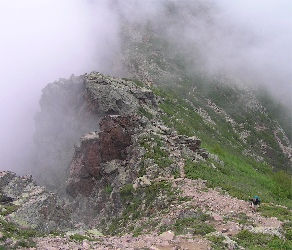
When we reached the col the terrain changed totally. The next section of the trail featured a ridge line of rocky spires that we needed to traverse to get to the head of the next valley. The other change that hit us at this point was in the weather. Here's the last photo I took on Thursday showing Paula (the dot in the lower right) ascending the col:
We'd just climbed up round the head of the valley to the right and clambered over the crop on the left centre, while the severe drop to the left forms the head of the next valley we had to skirt.
As we rounded the col and headed over towards the ridge line the gathering cloud turned to hail. Expecting the sort of hail that you get at home, which spatters against your windows or windscreen for 10 minutes and then stops, we put our cagouls on over our vests.
The trail line next weaves sinusoidally along the rocky crest, periodically switching from one side of the ridge to the other. In fine weather this would give you a tremendous view either side of the ridge line across a dramatic mountainscape, and we did initiallly get a sense of it. However, as the cloud closed in all that we could see were the steep slopes on either side. At some surreal moments we could still see distant lowlands running right down to the coast in glorious sun even as black clouds and hail encircled us.
Walking along the ridge was not straightforward. Usually this would be challenging in an exhilarating way, in the way that the girls enjoy scrambling over those rocks at the beach that you're worried might just be a little bit too dangerous. As we continued, though, the hail just came on harder and harder and started to settle quickly. At one point I cupped my hand to give Paula a boost and, even though we were in one of the most sheltered spots, by the time Paula had declined the offer my cupped hands were already full of large hailstones. (Surprisingly, since I found many of the hoists over the rocks a stretch, it turned out that Paula never needed help.) The rocks lost traction, we didn't know whether the hail we stood on was firm and our hands started to become numb with cold. And we were at over 2000m with severe drops either side.
The books all advise you to give these sections a miss if the weather is bad. They don't tell you what to do if you're up the top and it's just as hard to return as to continue. The first decision was when to take off our cagouls - thus losing the layer of trapped warm air - to put our fleeces on to retain more heat. Fortunately, we made this trade at a sensibly early juncture. The other decisions were harder. At what point do you stop and wait for the weather to pass? You'd lose daylight and heat and watch the hail pile up on the ground all the time you stood still but there must be a point at which continuing is too risky. Then is there a point at which you bivvy out? Again, you'd only be getting colder while you lay there but you must reach a time when it's the least dangerous thing to do. And what about trying to find a route directly down off the mountain? The plus is that you could try to find a spot where there was more favourable weather and less risk of accident, but you would be likely to get lost and much less likely to be found if it ever comes to a search. (Unlike our walks in England where we rely on map-reading, since the GR's are so well signed we don't pack maps.)
Most of the other walkers had already completed this stage by the time the hail came down. The Irish lads were the only other people we saw up there: they came past just after the hail started and before it got too troubling. It turned out that they were squaddies, one of whom is an ex-member of the French foreign legion (the muscular guys who run all over the GR20) and another of whom is a professional mountaineer. Although not pounding along at their pace we made good progress along the ridge-line through the hail, warming up our fingers as best we could and resisting any temptation to take a break. Eventually, after a couple of hours, the hail stopped. I felt warm in my fleece, I could see the clearing views, I ate half of one of Dr Gillian McKeith's energy bars (a high-tech taste-positive Kendal mint-cake) and felt terrific. We soon finished traversing the crest and descended to the col at the head of the valley leading down to the refuge de Carrozzu, our Thursday night destination.
The descent down the valley is described by Lonely Planet as "tedious". In fine weather I can imagine that it may be an enjoyable end to the day's walking as the vegetation soon picks up again and the trail passes through the lush aromatic shrubs and trees of the maquis. But when it's wet you can't spend too much time admiring the scenery. The path alternates between loose (wet) granite scree and smooth (wet) granite boulders. Wet granite has very little adhesion, as some of you will know from your kitchen work surfaces, and if you're walking downhill on an uneven friction-less surface you're likely to take a few tumbles. I escaped but Paula fell into a spiral of tiredness leading to falls leading to bruising leading to more tiredness leading to more falls. We ended up taking the last stage extremely slowly, and by the time we reached the refuge we'd been walking for 10.5 hours.
We threw our bags down, checked in and each had a large bowl of hot spiced wine. The others, who had only had a quick soak of rain at the end of their final descent, had been a little concerned about us and clapped us cheerily as we walked in. Our gear had been excellent - our cagouls, which are so much lighter than any I've had before, kept our upper bodies bone dry, our fleeces kept us warm and our boots remained dry and comfortable all day. Considering the amount of back and shoulder trouble I've had in the past, my rucsac had been remarkably untroublesome, too.
Over dinner we sat down and discussed what to do the next day. By morning there was no choice. We had another day of similar walking ahead, followed after that by the day that most walkers fear. (There is a hanging valley you have to scramble in and out of called the Cirque de la Solitude, and, having done, it unlike the other walkers in the refuge, I recall that the most fearsome aspect of it is the name; but it's not a walk in the park - except that technically it is.) And the weather was forecast to be the same. Since Paula was still sore, bruised and exhausted from the previous day we couldn't continue.
In planning our exit we benefited from the difficulty of fitting the whole walk into two weeks. Even in our party only the French couple, to my knowledge, planned to walk all the way to Conca, the remainder planning to finish at Vizzavona. The reason for this is boringly logistical - by the standard route it's a 15 day walk, and in reality you really need to find a way to squeeze in a rest day. And most people come to Corsica on flights that arrive and depart a fortnight apart. Accordingly, when Pete and I did the walk previously we took an alternative route that by-passes the refuge d'Ortu di Piobbu and gets you straight to the refuge de Carrozzu on the first night. (Even then we had to haul up at Vizzavona.) Anyhow, this alternative route passes through the Auberge de la Foret at Bonifatu, and Paula and I took the path back down to here, arriving well in time for lunch. It's a lovely place where I've headed to a few times over the years; approaching from the top you run into day-trippers coming to bathe in the mountain stream, which is bracing and fun. If you ever want to do a three day GR20 taster walk, which is practical over a long weekend if you can get the flights, I can recommend starting at Calenzana (which is close to Calvi airport), walking the first two days of the GR20 as we did and then returning to Calenzana by way of Bonifatu on the third.
After lunch we got a taxi back to Calvi.
Even before we had left Carrozzu we were thinking about how to recover, since we now have an opportunity that's rare this year to do something like this. We have a hotel booked for a couple of nights at Vizzavona where Paula's parents were due to meet us with the girls. Today we've been buying new maps, checking out local transportation (by boat, bus and rail) and trying to devise alternative walks that will land us at Vizzavona at the intended time on Thursday. We have to balance doing what is possible and what is desirable against the improving state of Paula's legs and feet. As of now we think we have it: we're taking a bus round to Porto on Monday afternoon then walking from Ota to Evisa by way of the Mare e Monti and then picking up the Mare e Mare Nord to Corte. This gets us in in time for the 4 p.m. train from Bastia, which gets us to Vizzavona for 5 p.m. insha 'llah. We can meet the folks and have time for a shower and an aperitif before dinner. This then gives us an option on the south section of the GR20, which would be neat for me as I would then have completed all of the stages, including the alternative at the start. In an ideal world we'd even be able to fall in again with the French couple. (Failing this, it'll remain in my system and I'll have to do it another time - do you want to join me?)
In all likelihood our alternative route will be nicer walking than the GR20 since it's not all over such fierce terrain (though it does cross the GR20 and shares an overnight point) and we should have an opportunity to enjoy the fantastic Corsican flora (the maquis) and fauna (boar, mountain goats, wild cows - things you also eat). But "nice" or not, the GR20 remains special. Usually I pass on activities whose purpose seems to be the thrill of surviving danger or that feature prominent vertigo opportunities - you wont get me in a parachute or even a hot air balloon - but somehow this particular trail gets dispensation.
Yesterday late afternoon I went down to the beach with the girls and there were, unusually, lots of jellyfish around. Zoe also spotted an octopus, which left its rock as we watched. I think it's the first time I've ever seen one swim in the sea. I'm off there now to meet them again and have a swim before dinner.
Posted: Sat - June 11, 2005 at 03:31 AM
Quick Links
Links
Archives
XML/RSS Feed
Calendar
| Sun | Mon | Tue | Wed | Thu | Fri | Sat |
Categories
Comments powered by
Statistics
Total entries in this blog:
Total entries in this category:
Published On: Feb 08, 2006 06:20 PM
Total entries in this category:
Published On: Feb 08, 2006 06:20 PM